
Bunkers on the Air Ireland

Background
· Bunkers on the Air Ireland (EIBOTA) is an amateur radio programme for activating bunkers in Ireland (EI) by licensed operators to make contacts with other licensed operators worldwide.
· It combines the understanding of history, an awareness of geography and geographical features and the challenge of amateur radio communication.
· EIBOTA joined the WWBOTA family in January 2025.
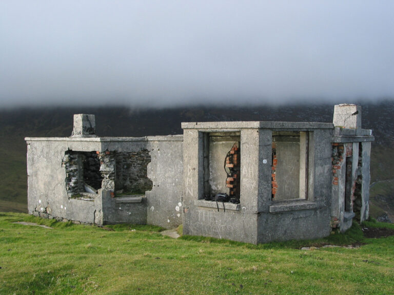
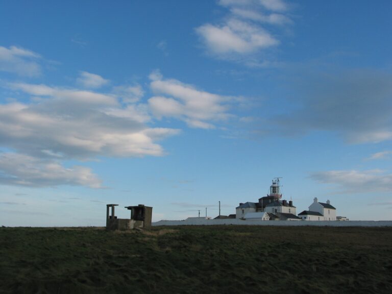
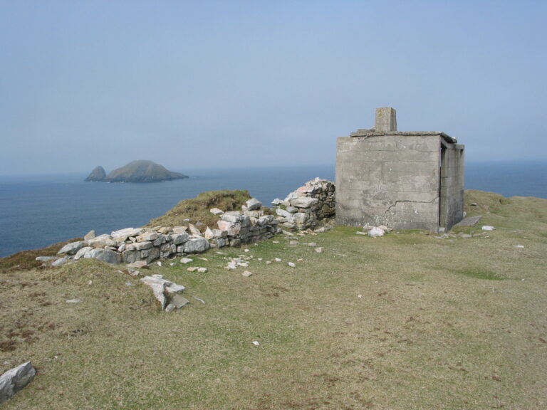
Dursey Head LOP (October 2003) (Michael Kennedy)
History
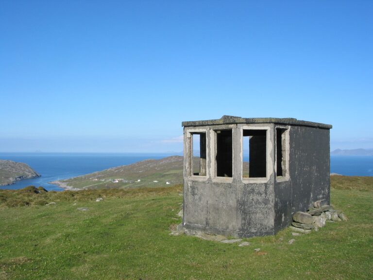
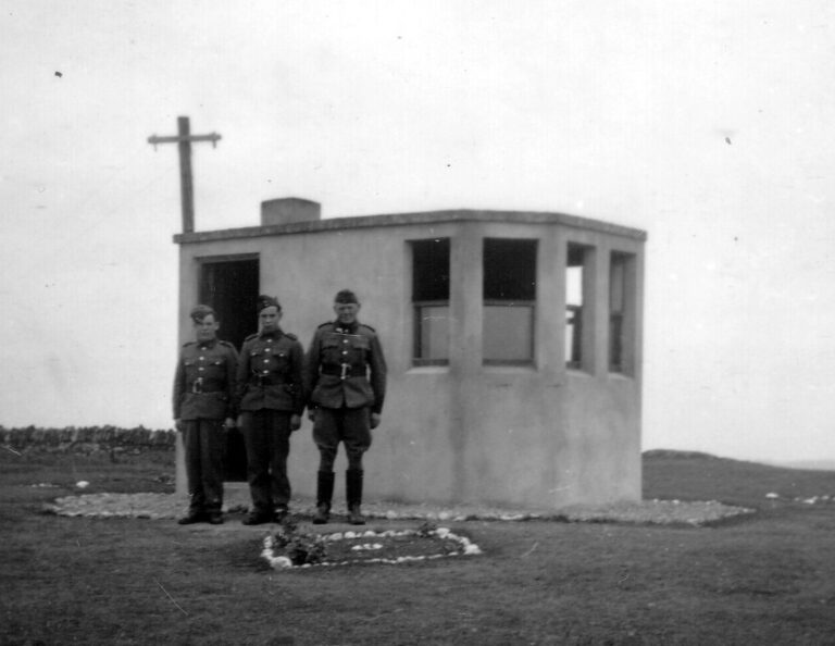
· During the second world war a network of coastal look out posts (LOPs) was established by the Irish Defence Forces as an anti-invasion watch.
· LOPS were continuously manned 24/7 365 days a year by members of the Marine and Coast Watching Service who reported all sightings on land, sea and in the air by telephone to local Defence Forces intelligence officers who in turn reported sightings to Defence Forces Headquarters in Dublin.
· The M&CWS was a low-tech Observer Corps created in a period where Ireland lacked an effective navy.
· The M&CWS enabled continuous real time reporting on events on any section of the Irish coast to senior military officers, government officials and ministers.
· Although Ireland was neutral in the second world war, its neutrality was strongly pro-Allied and information from the LOP network was often covertly provided to Allied diplomats in Dublin and to ‘friendly’ Allied governments.
· In 1945 the network of LOPs was closed down. A number of LOPs were designated as fallout monitoring positions in the 1960s and 1970s.
· Increasing interest in the history of LOPs in the 2010s and 2020s has led to a number being restored.
Further information and links
Irish Defence Forces
Tim Schmelzer LOP art project
Éire Signs’
Wikipedia
EIBOTA Reference List and Downloads
| Reference | Name | Latitude | Longitude | Locator | County |
|---|---|---|---|---|---|
| B/EI-0001 | Ballagan Point Lookout Post (LOP 1) | 53.996572 | -6.116272 | IO63WX | County Louth |
| B/EI-0002 | Dunany Point Lookout Post (LOP 2) | 53.86021 | -6.240024 | IO63VU | County Louth |
| B/EI-0003 | Clogher Head Lookout Post (LOP 3) | 53.795317 | -6.220422 | IO63VT | County Louth |
| B/EI-0004 | Cardys Rock Lookout Post (LOP 4) | 53.629461 | -6.187681 | IO63VP | County Dublin |
| B/EI-0005 | Rush Lookout Post (LOP 5) | 53.521081 | -6.076086 | IO63XM | County Dublin |
| B/EI-0006 | Howth Head Lookout Post (LOP 6) | 53.371108 | -6.055408 | IO63XI | County Dublin |
| B/EI-0007 | Dalkey Lookout Post (LOP 7) | 53.271389 | -6.093594 | IO63WG | County Dublin |
| B/EI-0008 | Bray Head Lookout Post (LOP 8) | 53.176125 | -6.074489 | IO63XE | County Wicklow |
| B/EI-0009 | Wicklow Head Lookout Post (LOP 9) | 52.965211 | -5.998242 | IO72AX | County Wicklow |
| B/EI-0010 | Kilmichael Point Lookout Post (LOP 10) | 52.734317 | -6.142656 | IO62WR | County Wexford |
| B/EI-0011 | Cahore Point Lookout Post (LOP 11) | 52.563278 | -6.19475 | IO62VN | County Wexford |
| B/EI-0012 | Ballyconnigar Hill Lookout Post (LOP 12) | 52.442164 | -6.315167 | IO62UK | County Wexford |
| B/EI-0013 | Greenore Point Lookout Post (LOP 13) | 52.240561 | -6.314939 | IO62UF | County Wexford |
| B/EI-0014 | Carnsore Point Lookout Post (LOP 14) | 52.175986 | -6.363769 | IO62TE | County Wexford |
| B/EI-0015 | Forlorn Point Lookout Post (LOP 15) | 52.173508 | -6.591747 | IO62QE | County Wexford |
| B/EI-0016 | Hook Head Lookout Post (LOP 16) | 52.123783 | -6.930308 | IO62MC | County Wexford |
| B/EI-0017 | Brownstown Head Lookout Post (LOP 17) | 52.128664 | -7.104181 | IO62KD | County Waterford |
| B/EI-0018 | Dunbratton Head Lookout Post (LOP 18) | 52.133139 | -7.306078 | IO62ID | County Waterford |
| B/EI-0019 | Helvick Head Lookout Post (LOP 19) | 52.052686 | -7.539056 | IO62FB | County Waterford |
| B/EI-0020 | Ram Head Lookout Post (LOP 20) | 51.942186 | -7.710056 | IO61DW | County Waterford |
| B/EI-0021 | Knockadoon Lookout Post (LOP 21) | 51.878956 | -7.871775 | IO61BV | County Cork |
| B/EI-0022 | Ballycotton Lookout Post (LOP 22) | 51.824186 | -8.011875 | IO51XT | County Cork |
| B/EI-0023 | Power Head Lookout Post (LOP 23) | 51.785383 | -8.173703 | IO51VS | County Cork |
| B/EI-0024 | Flat Head Lookout Post (LOP 24) | 51.716347 | -8.353133 | IO51TR | County Cork |
| B/EI-0025 | Old Head Lookout Post (LOP 25) | 51.606181 | -8.531342 | IO51RO | County Cork |
| B/EI-0026 | Seven Heads Lookout Post (LOP 26) | 51.570869 | -8.716059 | IO51PN | County Cork |
| B/EI-0027 | Galley Head Lookout Post (LOP 27) | 51.530556 | -8.953831 | IO51MM | County Cork |
| B/EI-0028 | Toe Head Lookout Post (LOP 28) | 51.489111 | -9.220444 | IO51JL | County Cork |
| B/EI-0029 | Baltimore Lookout Post (LOP 29) | 51.476014 | -9.352381 | IO51HL | County Cork |
| B/EI-0030 | Mizen Head Lookout Post (LOP 30) | 51.454333 | -9.813167 | IO51CK | County Cork |
| B/EI-0031 | Sheep's Head Lookout Post (LOP 31) | 51.546917 | -9.820981 | IO51CN | County Cork |
| B/EI-0032 | Dursey Head Lookout Post (LOP 32) | 51.598617 | -10.131469 | IO41WO | County Cork |
| B/EI-0033 | Lamb's Head Lookout Post (LOP 33) | 51.740661 | -10.131608 | IO41WR | County Kerry |
| B/EI-0034 | Bolus Head Lookout Post (LOP 34) | 51.792614 | -10.336289 | IO41TT | County Kerry |
| B/EI-0035 | Bray Head Lookout Post (LOP 35) | 51.885414 | -10.424925 | IO41SV | County Kerry |
| B/EI-0036 | Eask Head Lookout Post (LOP 36) | 52.115447 | -10.281725 | IO42UC | County Kerry |
| B/EI-0037 | Parkmore Lookout Post (LOP 37) | 52.108234 | -10.354308 | IO42TC | County Kerry |
| B/EI-0038 | Dunmore Head Lookout Post (LOP 38) | 52.110056 | -10.473583 | IO42SC | County Kerry |
| B/EI-0039 | Sybil Head Lookout Post (LOP 39) | 52.182961 | -10.464828 | IO42SE | County Kerry |
| B/EI-0040 | Brandon Point Lookout Post (LOP 40) | 52.288039 | -10.163597 | IO42WG | County Kerry |
| B/EI-0041 | Fenit Lookout Post (LOP 41) | 52.267231 | -9.862119 | IO52BG | County Kerry |
| B/EI-0042 | Kerry Head Lookout Post (LOP 42) | 52.411925 | -9.931608 | IO52AJ | County Kerry |
| B/EI-0043 | Leck Head Lookout Post (LOP 43) | 52.536589 | -9.670989 | IO52DM | County Kerry |
| B/EI-0044 | Kilcreadun Point Lookout Post (LOP 44) | 52.582242 | -9.709736 | IO52DN | County Clare |
| B/EI-0045 | Loop Head Lookout Post (LOP 45) | 52.560311 | -9.933817 | IO52AN | County Clare |
| B/EI-0046 | George's Head Lookout Post (LOP 46) | 52.701972 | -9.635786 | IO52EQ | County Clare |
| B/EI-0047 | Hag's Head Lookout Post (LOP 47) | 52.948533 | -9.466475 | IO52GW | County Clare |
| B/EI-0048 | Black Head Lookout Post (LOP 48) | 53.1539 | -9.264886 | IO53ID | County Clare |
| B/EI-0049 | Spiddal Lookout Post (LOP 49) | 53.241789 | -9.324883 | IO53IF | County Galway |
| B/EI-0050 | Kilronan Lookout Post (LOP 50) | 53.127592 | -9.701981 | IO53DD | County Galway |
| B/EI-0051 | Golam Head Lookout Post (LOP 51) | 53.230967 | -9.753119 | IO53CF | County Galway |
| B/EI-0052 | Mace Head Lookout Post (LOP 52) | 53.324717 | -9.900436 | IO53BH | County Galway |
| B/EI-0053 | Slyne Head Lookout Post (LOP 53) | 53.414917 | -10.114831 | IO43WJ | County Galway |
| B/EI-0054 | Auchrus Point Lookout Post (LOP 54) | 53.549333 | -10.166133 | IO43WN | County Galway |
| B/EI-0055 | Renvyle Lookout Post (LOP 55) | 53.603183 | -10.050192 | IO43XO | County Galway |
| B/EI-0056 | Rossroe Lookout Post (LOP 56) | 53.622386 | -9.866172 | IO53BO | County Galway |
| B/EI-0057 | Roonagh Lookout Post (LOP 57) | 53.763281 | -9.900239 | IO53BS | County Mayo |
| B/EI-0058 | Corraun Lookout Post (LOP 58) | 53.865161 | -9.904519 | IO53BU | County Mayo |
| B/EI-0059 | Moyteogue Head Lookout Post (LOP 59) | 53.963758 | -10.192839 | IO43VX | County Mayo |
| B/EI-0060 | Blacksod Bay Lookout Post (LOP 60) | 54.101475 | -10.083894 | IO44WC | County Mayo |
| B/EI-0061 | Annagh Head Lookout Post (LOP 61) | 54.241303 | -10.105539 | IO44WF | County Mayo |
| B/EI-0062 | Erris Head Lookout Post (LOP 62) | 54.300489 | -10.000108 | IO44XH | County Mayo |
| B/EI-0063 | Benwee Head Lookout Post (LOP 63) | 54.343039 | -9.780617 | IO54CI | County Mayo |
| B/EI-0064 | Downpatrick Head Lookout Post (LOP 64) | 54.327108 | -9.345475 | IO54HH | County Mayo |
| B/EI-0065 | Kilcummin Head Lookout Post (LOP 65) | 54.282936 | -9.214419 | IO54JG | County Mayo |
| B/EI-0066 | Lenadoon Point Lookout Post (LOP 66) | 54.279722 | -9.033994 | IO54LG | County Sligo |
| B/EI-0067 | Aughris Head Lookout Post (LOP 67) | 54.276381 | -8.768236 | IO54OG | County Sligo |
| B/EI-0068 | Rosskeeragh Lookout Post (LOP 68) | 54.348664 | -8.671772 | IO54PI | County Sligo |
| B/EI-0069 | Mullaghmore Lookout Post (LOP 69) | 54.468919 | -8.458194 | IO54SL | County Sligo |
| B/EI-0070 | St. John's Point Lookout Post (LOP 70) | 54.569433 | -8.456494 | IO54SN | County Donegal |
| B/EI-0071 | Carrigan Head Lookout Post (LOP 71) | 54.619792 | -8.678981 | IO54PO | County Donegal |
| B/EI-0072 | Rossan Point Lookout Post (LOP 72) | 54.700889 | -8.778406 | IO54OQ | County Donegal |
| B/EI-0073 | Dunmore Head Lookout Post (LOP 73) | 54.845292 | -8.485089 | IO54SU | County Donegal |
| B/EI-0074 | Crohy Head Lookout Post (LOP 74) | 54.918375 | -8.454569 | IO54SW | County Donegal |
| B/EI-0075 | Arranmore Point Lookout Post (LOP 75) | 55.01125 | -8.544914 | IO55RA | County Donegal |
| B/EI-0076 | Bloody Foreland Lookout Post (LOP 76) | 55.148994 | -8.289225 | IO55UD | County Donegal |
| B/EI-0077 | Horn Head Lookout Post (LOP 77) | 55.215855 | -7.977329 | IO65AF | County Donegal |
| B/EI-0078 | Melmore Head Lookout Post (LOP 78) | 55.236147 | -7.7996 | IO65CF | County Donegal |
| B/EI-0079 | Fanad Head Lookout Post (LOP 79) | 55.276853 | -7.632972 | IO65EG | County Donegal |
| B/EI-0080 | Malin Head Lookout Post (LOP 80) | 55.379411 | -7.378328 | IO65HJ | County Donegal |
| B/EI-0081 | Glengad Head Lookout Post (LOP 81) | 55.335489 | -7.171328 | IO65JI | County Donegal |
| B/EI-0082 | Inishowen Head Lookout Post (LOP 82) | 55.235492 | -6.924672 | IO65MF | County Donegal |
| B/EI-0083 | Foileye/Feaklecally Lookout Post (LOP 83) | 52.022303 | -10.140061 | IO42WA | County Kerry |
The EIBOTA bunker references can be viewed on the Google Map below or downloaded as a KML file here:
EIBOTA is work in progress
· The EIBOTA bunker list is work in progress and currently reflects only the Look Out Posts (LOPs) of the Irish Defence Forces second world war Marine and Coast Watching Service.
· Any corrections or comments should be addressed to the EIBOTA Coordinator below.
· Bunkers, pill boxes, coastal defence forts and other relevant sites will be added later.
Clogher Head LOP (No. 3), February 1940 (Courtesy of the National Archives of Ireland (OPW Collection))


Dunbrattin Head LOP (No. 18), February 1945 (Courtesy of the National Archives of Ireland (OPW Collection))
Kilcreadaun LOP (No. 44), 23 July 1941 (courtesy of National Archives (OPW Collection))
Activity and participants
· The main goal of the programme is the enjoyment of activating and hunting bunkers.
· EIBOTA is not a contest.
· Amateur operators can participate as Activators and/or Hunters.
· SWL (Short wave listeners) are also encouraged to participate.
· All bands and modes are valid according to the license of the operators and the regulations in Ireland.
· Bunkers must be activated in person.
· No repeaters may be used for EIBOTA QSOs.
· The programme is based on the personal integrity of the participants.

Safety and Permissions
· All EIBOTA activity is the responsibility of the participants. Activations are made at activators own risk. Activators are responsible for their own safety.
· Activators should be aware that the structures listed herewith, being built in 1940, are now in fragile condition and may be unsafe to enter. Masts and antennae should not be attached to them.
· The listing of a bunker in the EIBOTA reference list does not in anyway indicate that a bunker, or the vicinity of a bunker, is either safe or legal to enter.
· Activators enter LOPs and other EIBOTA referenced structures at their own risk, should conduct a personal safety assessment before conducting an activation and obtain the permission of the relevant landowners if the activation site is on private property.
· Activators should assess weather conditions before making activations and be aware that weather conditions in coastal regions of Ireland change, generally for the worse, rapidly and continually.
· EIBOTA accepts no responsibility for any issues arising from the activation of a bunker.
Activators
· Activations must be within 1 kilometre of the given bunker coordinates.
· Only one EIBOTA reference can be activated at a time.
· 15 QSOs obtained in one unique activation are required for a bunker activation to be valid.
· Activation from the home shack is not permitted.
· Activation from inside a vehicle is permitted.
· Activators, Hunters and SWLs are NOT obligated to send their logs to EIBOTA.
Hunters
· Every QSO is valid for Hunters and SWLs regardless of whether the Activator achieves the minimum number of QSOs for that activation.
Awards
· Initially EIBOTA will not issue separate awards.
· All awards for EIBOTA activations, and hunting EIBOTA bunkers are, however, eligible for WWBOTA Awards.
Éire Sign
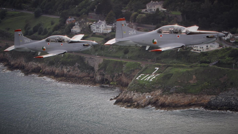
If you activate an EIBOTA LOP location you may well see the large white painted stone ‘Éire Sign’ close by. ‘Éire’ is ‘Ireland’ in the Irish language. The signs were originally to alert pilots they were over neutral Irish territory. With the addition of a number to each sign (at American request) they became daytime aids to navigation to Allied pilots crossing the Atlantic in the run up to D-Day who were supplied with maps of the Irish coast with the locations of the numbered signs marked. Here two Pilatus PC-9M advanced trainers of the Irish Air Corps fly by the restored ‘Éire Sign’ at LOP No. 7 at Dalkey (courtesy of the Irish Air Corps)
EIBOTA Coordinator
All correspondence and award requests should be sent to:
Michael Kennedy (EI6IRB) Michael.J.Kennedy.70@gmail.com
Portacloy LOP (No. 63), April 2003. Known locally as ‘Teacháin a’Watch’ (‘the Watch House’ in Irish), it has recently been restored. See www.lop63.com (Michael Kennedy)